
CONVENIENTLY LOCATED
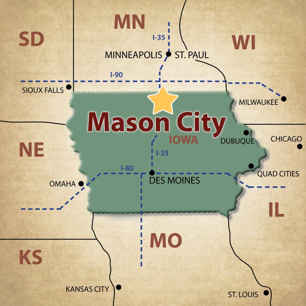 Located in North Central Iowa, Mason City is conveniently located halfway between Des Moines, Iowa and Minneapolis/St. Paul, Minnesota, just 8 miles east of Interstate 35. The Avenue of the Saints (Highway 18/US 27) is located just minutes South of City limits.
The community has two main corridors – Highway 65 which runs north/south and Highway 122 which runs east/west; and connects the communities of Mason City and Clear Lake.
The Mason City Municipal Airport is conveniently located between Mason City and Clear Lake (just 3 minutes off I-35), along Highway 122, and provides four commercial flights daily.
Mason City is 45 minutes from Interstate 90 and 2 hours away from Interstate 80. In addition, Mason City is in close proximity to other larger metropolitan areas.
MILES FROM MASON CITY
Iowa Cities | Distance | Estimated Drive Time | Midwest Cities | Distance | Estimated Drive Time |
| Burlington, IA | 249 | 4 hours 22 minutes | Chicago, IL | 337 | 6 hours 20 minutes |
| Cedar Rapids, IA | 146 | 2 hours 22 minutes | Fargo, ND | 365 | 5 hours 40 minutes |
| Council Bluffs, IA | 245 | 4 hours | Kansas City, MO | 312 | 5 hours |
| Des Moines, IA | 120 | 2 hours | Madison, WI | 299 | 4 hours 45 minutes |
| Dubuque, IA | 164 | 3 hours | Milwaukee, WI | 371 | 5 hours 50 minutes |
| Iowa City, IA | 164 | 2 hours 50 minues | Minneapolis, MN | 135 | 2 hours |
| Quad Cities, IA | 223 | 3 hours 45 minutes | Omaha, NE | 253 | 4 hours |
| Sioux City, IA | 197 | 4 hours | Rochester, MN | 97 | 1 hour 45 minutes |
| Spirit Lake/Okoboji, IA | 116 | 2 hours 40 minutes | Sioux Falls, SD | 207 | 3 hours 25 minutes |
| Waterloo/Cedar Falls, IA | 81 | 1 hour 25 minutes | Springfield, IL | 462 | 6 hours |
| St. Louis, MO | 436 | 7 hours 45 minutes | |||
| Wichita, KS | 502 | 7 hours 50 minutes |
MASON CITY MAPS
PRINT-FRIENDLY VISITOR MAP: Mason City offers a variety of sightseeing opportunities, a vast trail system, and a unique architectural/historical walking tour. This map identifies the major road routes within the community, the City’s all-purpose trail system, an enlarged downtown map featuring the Prairie School/Historical Architectural self-guided walking tour route, and locators pinpointing the major areas of interest and lodging facilities.
DOWNTOWN SHOPPING MAP: Features numerous shopping options in Mason City’s historic downtown with parking locations and time limits noted.
DOWNTOWN DINING MAP: Highlights the variety of dining establishments located within the heart of Downtown Mason City.
ARCHITECTURAL WALKING TOUR: Easy-to-use map leads visitors on a self-guided walking tour of the community’s architectural gems and historically significant buildings throughout the greater downtown Mason City area.
SCULPTURE WALK: Self-guided tour starts in the Downtown and loops through the Cultural Crescent which is also home to many of the community’s historical architecture, Art Museum, public library, Music Man attractions, and the unique works of art from sculptors from around the country.
MURAL MAP: Explore the Frank Lloyd Wright-inspired murals and other colorful works of art that have transformed buildings throughout the community.
MASON CITY BIKE TRAILS & CLEAR LAKE BIKE TRAILS: Enjoy multi-purpose trails located in and around Mason City and Clear Lake.
NORTH IOWA SNOWMOBILE MAP: Highlights over 100 miles of snowmobile trails in the North Iowa area.